Plymouth Hoe is one of those places I’ve been around before, but I don’t think I’d ever properly slowed down and looked at everything there.
I knew there were sea views, Smeaton’s Tower, memorials and all the obvious bits — but once I started following the trail, there was so much more tucked into it than I expected. Old defences, hidden stories, naval history, little details I’d probably walked past before without thinking twice.
This walk isn’t a serious hike or anything dramatic. It’s more of a slow wander around the Hoe and nearby waterfront, taking in places like Sutton Harbour, the Royal Citadel, Drake’s Island, Tinside Lido, and a lot more history than I realised was sitting right there.
ℹ️ Trail at a Glance:
Location: Plymouth, Devon
Start/End point: Sutton Harbour by Mayflower Steps
Walk type: Easy city and waterfront walk
Time needed: Around 1-2 hours, depending on how often you stop
Difficulty: Easy – moderate, with some steps depending on the route
Best for: Sea views, local history, photography, memorials and a slow wander
Good to know: This is more of a relaxed wander than a serious hike, with plenty of places to stop, take photos and look around, and there is ample parking, usually paid, all around Plymouth
Stop 1: Sutton Harbour

Sutton Harbour is one of those places in Plymouth you can easily walk through without thinking too much about it, with boats, water, cafes, pubs and people wandering around, you wouldn’t imagine how much history is hidden everywhere. It used to be known as Sutton Pool, and it sits where the original fishing village of Sutton once was. The name “Sutton” means “South Town,” which actually makes sense when you look on the map where it is.
Fishing played a significant part in Plymouth’s history, especially by the 16th century, when it became one of the main ways the area made money. As time passed, fishermen began travelling further out to sea and trawling was introduced – basically boats pulling large weighted nets along the seabed.
You’d never believe there was a full working railway here too! This made a big difference as it meant fish could be transported to the London Market so much easier.
So Sutton Harbour wasn’t just a pretty place by the water; it was (and still is) a proper working harbour. It was a really important part of Plymouth’s growth back in the day. To this day, Plymouth is still an important shipping port as well as a naval base, making the area feel layered with the old and new versions of the city mixed together.
Next: Head up Madeira Road slightly on the right, walk up the steps and turn right towards Plymouth Castle.
Stop 2: Plymouth Castle
Oh my gosh, I was expecting a little more at least, but Plymouth Castle is so easy to miss if you’re not actively looking for it because only a small part of it still remains today.
It was built in the late 1300s to help defend Sutton Harbour after repeated raids by the French. With Plymouth being such an important coastal and naval location, it makes sense that it needs protecting.
The castle stood for around 300 years until it was demolished in 1665. Now all that’s left are two small sections and the base of a gatehouse, which you can still see today.
There really isn’t much to see, it’s crazy; a little historic spot that doesn’t seem huge but once you know what it was there for then it feels more important. And as you look out across the Plymouth Sound, you can see how much of the coastline was shaped by defence, forts and naval history.
Next: Go back the way you came, head right up Lambhay Hill, toward the entrance of The Royal Citadel.
Stop 3: The Royal Citadel
The Royal Citadel is hard to miss. Sitting high above Plymouth Sound, it feels much more dramatic than the small remains of the Plymouth Castle previously seen. The Citadel replaced the castle as the city’s main military defence in the 1660s, when Charles II wanted Plymouth protected from possible attacks by the Dutch.
Awkwardly, the man who designed it, Sir Bernard de Gomme, was Dutch himself. A little ironic and I wonder how it happened, but clearly he knew what he was doing. The Citadel had an unusual star-like shape, partly because it incorporated an older Elizabethan fort. The points of the star, called bastions, helped defend Plymouth from different angles.

The main entrance dates back to the 1660s and was designed by Sir Thomas Fitz. It’s known for its Baroque style, which gives it a lot more detail than you might expect from a military fortress.
Today, the Royal Citadel is still used by the military and is home to the 29 Commando Regiment of the Royal Artillery.
Next: Follow the road around the Citadel, taking Hoe Road and heading up towards the lighthouse, Smeaton’s Tower.
Stop 4: Smeaton’s Tower
Probably one of, if not the most famous sight in Plymouth is Smeaton’s Tower so it feels very fitting that it sits upon the Hoe – especially for a walk called the Hoe Trail!
It was designed by John Smeaton and originally built on the Eddystone Reef, around 14 miles southwest of Plymouth. Construction began in 1756 and the lighthouse was completed in 1759 at a cost of £40,000.
Instead of it being lost completely, around two-thirds of the lighthouse was moved stone by stone and rebuilt on Plymouth Hoe during the late 1800s, where it still stands today.
On a clear day, you can still see the current Eddystone Lighthouse out on the horizon beside the old base of Smeaton’s Tower. I love that little detail – the old one on the Hoe, the newer one still out at sea, both linked to the same story.
Next: Turn 180 degrees, across The Promenade, where you’ll see the memorials.
Stop 5: Memorials
Plymouth has played a huge role in Britain’s military and naval history, so it makes total sense that the Hoe has several memorials looking out across the water. The Hoe itself was once a restricted military area before becoming a more public space during the Victorian era, with gardens, promenades and places for people to gather together.
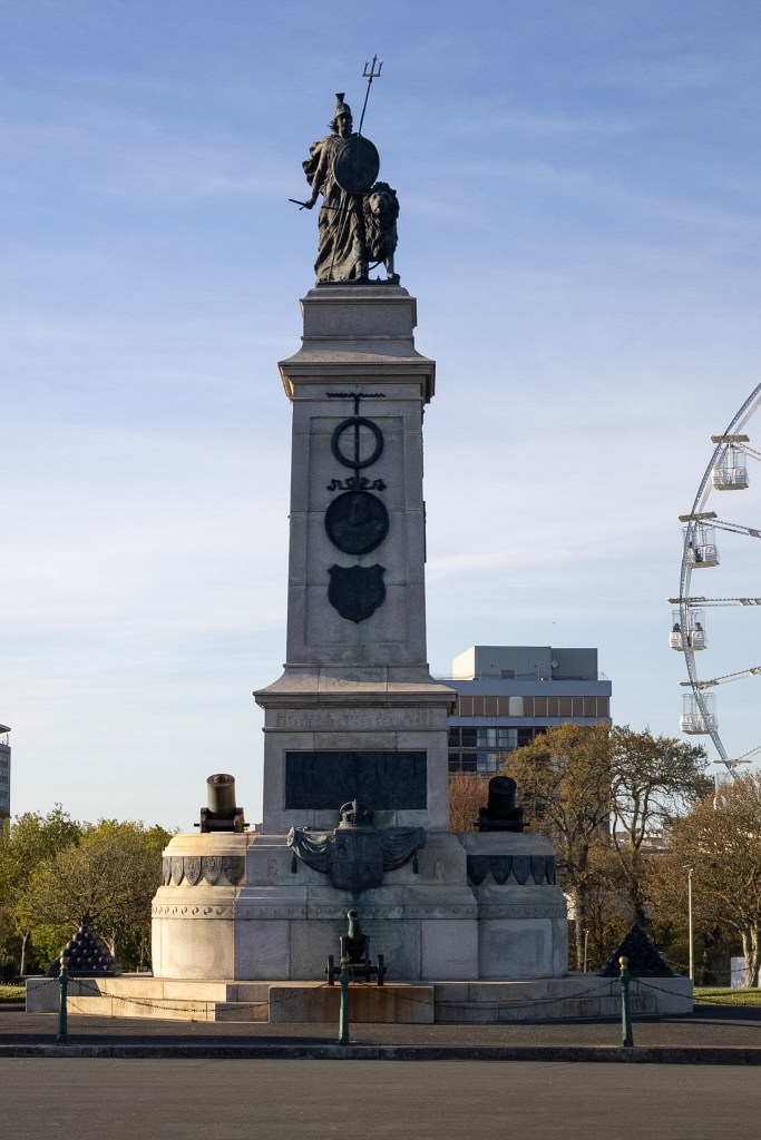
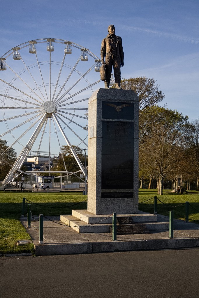
Just opposite Smeaton’s Tower, across the promenade, there are four main memorials:
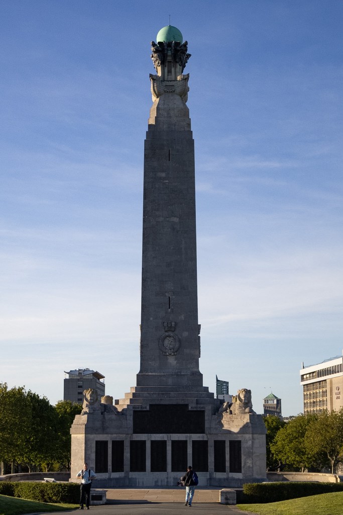

- The biggest is the Plymouth Naval Memorial, unveiled in 1924 to remember sailors who died during World War I. It originally listed around 7200 names, with thousands more added after WW2. It’s quite a lot to take in when you remember each name was a real person, with a life, family and story.
- There is also the Merchant Navy Memorial, unveiled in 2019 for the men and women of the British Merchant Navy and fishing fleets.
- The Armada Memorial was built in 1888, 300 years after the defeat of the Spanish Armada. The figure at the top, her name is Britannia, and she represents Britain in human form.
- Lastly, the Royal Air Force and Allied Air Forces Monument was unveiled in 1989, remembering those who lost their lives during WW2.
This part of the Hoe feels a little heavier than the rest of the walk, but it is totally worth slowing down for and paying respects to those thousands of people who lost their lives so we can live our lives today.
Next: The Drake statue sits left to all the memorials you just looked at.
Stop 6: Drake Statue
Sir Francis Drake stands high on Plymouth Hoe, frozen in place like a… oh, right, a literal statue for sure.
The statue was unveiled in 1884, around 300 years after the defeat of the Spanish Armada. Why Plymouth has more than one monument linked to the Armada, I’m not fully sure – but clearly, it was a big deal.
Drake also helped bring fresh water to Plymouth through Drake’s Leat, which carried drinking water from Dartmoor to the town. But, like a lot of historical figures, his story isn’t simple. Although he was celebrated as a hero, he was also a privateer and had links to the slave trade.
So, this statue feels like one of those stops where the history is interesting but also a bit uncomfortable, and probably worth looking at properly, not just walking past.
Next: When you’re ready, walk back to the other side of The Promenade, where it juts out a little to look out toward Plymouth Sound.
Stop 7: Plymouth Sound
On a dry, summery day, the view across Plymouth Sound is honestly beautiful. From the Belvedere, with its collonaded terraces completed in 1891, you get one of those wide open views that makes you stop for a minute.


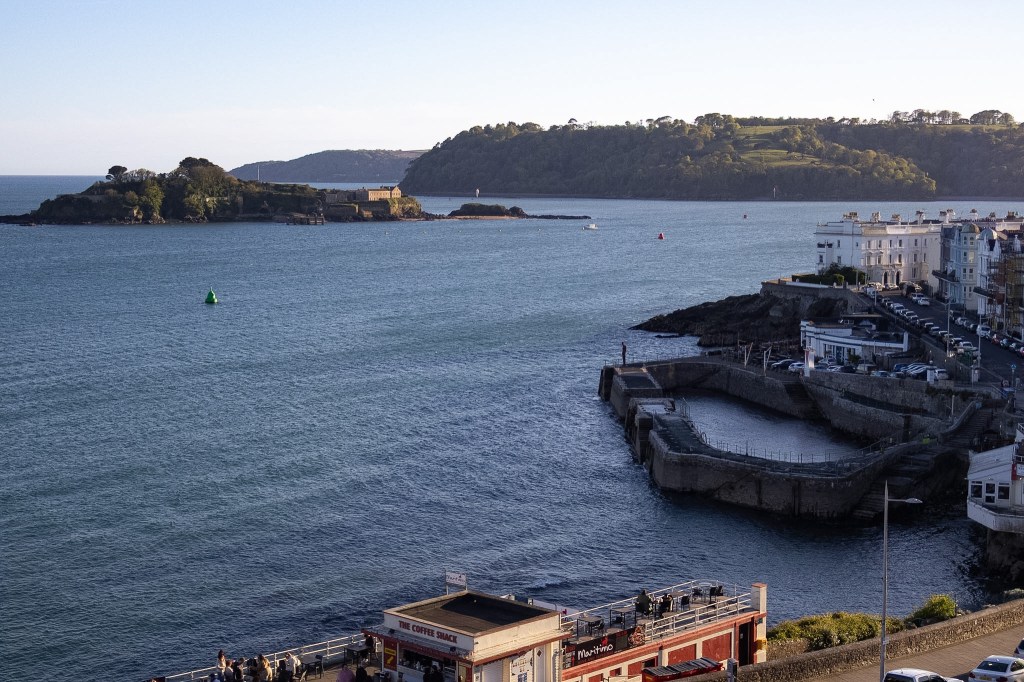
You can almost read the Sound like a book, from left to right.
To the east, you can see Mount Batten, with the Cattewater breakwater stretching out to help protect the harbour. Further along are Staddon Point Battery and Bovisand Fort, both part of Plymouth’s coastal defences.
Out across the water sits Plymouth Breakwater, which took 37 years to build and used around 4.5 million tons of stone. Which is absolutely wild when you actually think about it.
Then there’s Drake’s Island, the Rame Peninsula over in Cornwall, and Mount Edgecumbe on the closest headland across the Tamar.
Standing here, it’s one of those views where the longer you look, the more you realise is actually there.
100% recommend! And you could even get an ice cream to enjoy it with.
Next: Keep going along the Hoe, turning around, heading towards the exit on the right-hand side, but take a second to look at Elliot Terrace before leaving.
Stop 8: Elliot Terrace
Built in the 19th century, Elliot Terrace was designed to make the most of that incredible view across Plymouth Sound, and honestly, it makes sense why!
A couple of well-known names are linked to the terrace too:
- Number 6 briefly lodged Sir Arthur Conan Doyle, the creator of Sherlock Holmes.
- Number 3 was home to Lord and Lady Astor. Waldorf Astor inherited his father’s seat in the House of Lords, which meant Nancy Astor stood in her partner’s place in the House of Commons. She went on to become the first woman to take her seat as an MP.
Not a bad bit of history for one row of houses with a sea view.
Next: Exit the Hoe, going left, down Hill Road about halfway, when you can step left, looking out onto West Hoe Park, where West Hoe Quarry used to be.
Stop 9: West Hoe Quarry
Looking out over West Hoe Park, it’s strange to think this area was once a limestone quarry.
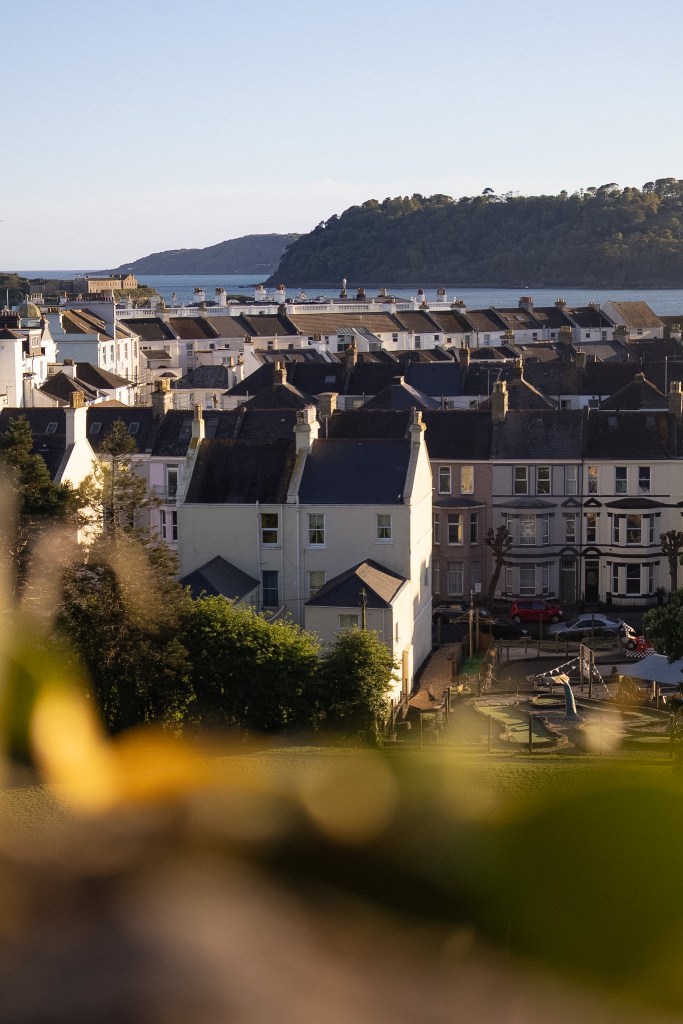
In the 19th century, it was owned by Thomas Gill, who had links to both the South Devon Railway Company and the Plymouth Great Western Docks Company. Because of this, a pier and railway were built at Millbay to help move the limestone.
You can still see the arches in the seawall today, showing where stone was moved through tunnels and loaded onto ships. Some of this stone is thought to have been used for Plymouth Breakwater.
When the quarry closed, Gill imagined the area becoming the West Hoe Estate. The land was sold off in sections, which is why the terraces don’t all look the same.
After the Blitz, plans to redesign Plymouth also reached West Hoe, leading to some Victorian houses and recreational gardens being demolished.
Next: Continue down Cliff Road to the end, crossing over to the wall in front of Millbay.
Stop 10: Millbay
Over the wall is Millbay, and if you want a better look, you can take a little detour down the steps to the right. From there, you can see the ferry terminal and Millbay Docks.
In the 19th century, Millbay was Plymouth’s main port, especially for large ocean liners carrying mail and passengers. It would have been a busy place, full of travellers, traders and people coming and going by sea.
Thomas Gill, who owned West Hoe Quarry, also had links to Millbay. He built a pier there in the 1840s to support his businesses, including Millbay Soap Works, which had been set up in 1818. The railway arrived soon after, making the area even more connected.
One of the more striking stories linked to Millbay is that in 1912, survivors from the Titanic were brought here after the ship sank. From Plymouth, many continued the rest of their journey home by train.
Later, in the 1970s, Brittany Ferries began operating from Millbay Docks, with routes to places like Roscoff in France and Santander in Spain.
As you carry on, you’ll also pass Plymouth Lifeboat Station, which is housed in the former customs house and police station.
Next: If you haven’t gone down the steps, you will want to go left along Great Western Road, continuing onto Grand Parade until you are able to turn right, follow that extra path around to the end, taking in the sight of Drake’s Island.
Stop 11: Drake’s Island

One of the most noticeable features when looking out across Plymouth Sound is Drake’s Island. It has been known as Drake’s Island for hundreds of years, but before that, it was called St Michael’s Island, after a chapel was built there in the 12th century. It was also known as St Nicholas Island for a while too.
Like a lot of Plymouth’s coastline, the island has been shaped by defence. It was fortified from the 16th century to protect against French and Spanish attacks, and was last used for defence during WW2. It was garrisoned by almost 500 soldiers – that’s a lot of people on that little island!
It was also used as a state prison for around 25 years from 1660, although apparently only 12 prisoners were ever held there.
There are also local legends about underground tunnels running between Plymouth, Cornwall and the island, but there doesn’t seem to be any real evidence of them beyond the tunnels on the island itself.
After the war, the island was used as a youth adventure training centre from 1964 to 1989. Today, it is privately owned and open for guided tours and special events, so you can actually visit rather than just stare at it from the Hoe, wondering what’s over there.
Next: Make your way along to Hoe Road, walking up until you get in front of the Belvedere, where you stood earlier, to look onto the site of the Promenade Pier.
Stop 12: Promenade Pier
The foreshore has layers of human history; sculpted by the sea, quarried for stone, and endlessly remodelled to meet people’s changing leisure needs.
During the Victorian era, this area became much more focused on leisure. The Promenade Pier opened in 1884, costing £45,000 and funded by the people of Plymouth. It had a working clock tower, shops and a landing stage for pleasure steamers.
In 1891, a pavilion was added to the end of the 146 metre pier, with space for around 2000 people. It hosted entertainment like concerts, dancing and roller skating, which honestly sounds like it would have been such a busy spot. The same year, the collonaded Belvedere was built nearby to line up with the pier.
By the 1930s, the pier was struggling financially, partly because of competition from newer attractions like cinemas. It was later bombed in 1942 and eventually demolished in 1953.
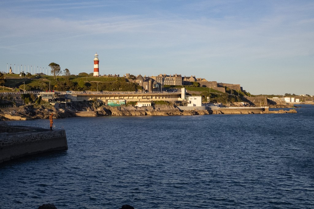
Today, the foreshore looks completely different, with paths, steps and bathing pools. But if you know the history, you can still imagine how lively it must have been.
Next: Follow the waterfront towards the Tinside Lido, coming up the hill slightly to the left.
Stop 13: Tinside Lido
Bathing was a major pastime in Plymouth, particularly between the wars. With shorter working hours and paid holidays becoming more common, people had more time to enjoy places like the Hoe.
Tinside Lido opened in 1935 as an Art Deco bathing pool with pavilions, changing rooms, terraces and the pool itself. It was originally built as a ladies’ bathing pool, while the nearby “Lion’s Den” was used as a gentlemen’s bathing area.
After the war, bathing was still popular as a way to cool off, swim and spend time by the sea. Unfortunately, the lido was then closed in 1992, given Grade II listed status in 1988, and later reopened in 2005… after a £3.4 million investment.
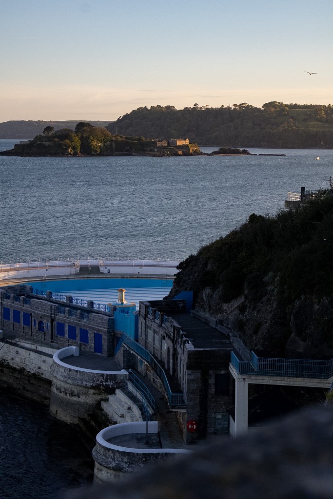
It’s such a beautiful part of the waterfront now and one of those places that really gives Plymouth Hoe its seaside character.
Next: Stay on the main path, heading around to the right. As you get onto Madeira Road, you’ll see a building up on the hill to the left. This is the Marine Biological Association.
Stop 14: Marine Biological Association
Plymouth Sound’s combination of coast, open waters and river estuaries have been attracting scientists throughout history, and it’s easy to see why, becoming a really important place for marine life.
The Marine Biological Association was founded in London in 1884 to support marine science and raise concerns about overfishing. In 1888, it opened a laboratory and aquarium in Plymouth, helping to establish the city’s modern role in marine research. The Association’s first director was Professor Thomas Henry Huxley, a strong supporter of Charles Darwin’s theory of evolution.
The original aquarium was later modernised, but ended up closing to the public. Work then began on the National Marine Aquarium in 1997, continuing Plymouth’s link with marine science and education.
Most recently, Plymouth Sound has been recognised as the UK’s first National Marine Park, highlighting its protected habitats, wildlife, views and many different uses from commercial ports to military activity.
It’s all a reminder that Plymouth Sound isn’t just beautiful to look at – there’s a whole world of science, wildlife and history beneath the surface too.
Next: Continue on the same path until you reach a tiny jut with two cannons which were once part of Plymouth’s coastal defences.
Stop 15: Coastal Defences
The Royal Citadel once dominated this part of the foreshore, protecting the approach to the harbour and replacing an earlier Elizabethan fort.
Nearby is Fisher’s Nose, built in 1847 as an ammunition store and guard house for the Citadel’s defences.
This area is also linked to the wreck of the Dutton, an East India Company ship that ran aground in 1796. There were hundreds of people on board, but only a small number of lives were lost thanks to the actions of a Royal Navy captain.
Stories like this show how dangerous Plymouth Sound could be, and why stronger protection, including Plymouth Breakwater, became so important.

Across the water, you can also spot Mount Batten Tower, built in 1652, and the Cattewater Breakwater, completed in 1881.
Next: From here, follow the road back down to Sutton Harbour to complete the circuit of the Hoe Trail.
I hope you enjoy this walk as much as I did. If you follow the trail, I’d love to know your favourite stop or any hidden gems you discover along the way.
Until next time xXx


Leave a Reply